Skip to content

This weekend: Little Italy Mercato · Sat 8am–2pm · Free

The San Diego List*
WEEKEND
Things to Do · Day Trips

The Anza-Borrego Day Trip, Planned for the Cool Months: 7 Stops

The Slot at first light, a ranger briefing, Palm Canyon to the viewpoint over the fan palms, lunch indoors, 130 sculptures on the valley floor, and a sky with nothing in it.

7 stopsUpdated Jul 27, 2026 Verified Jul 19, 2026By The San Diego List
NeighborhoodsBorrego Springs & Anza-Borrego

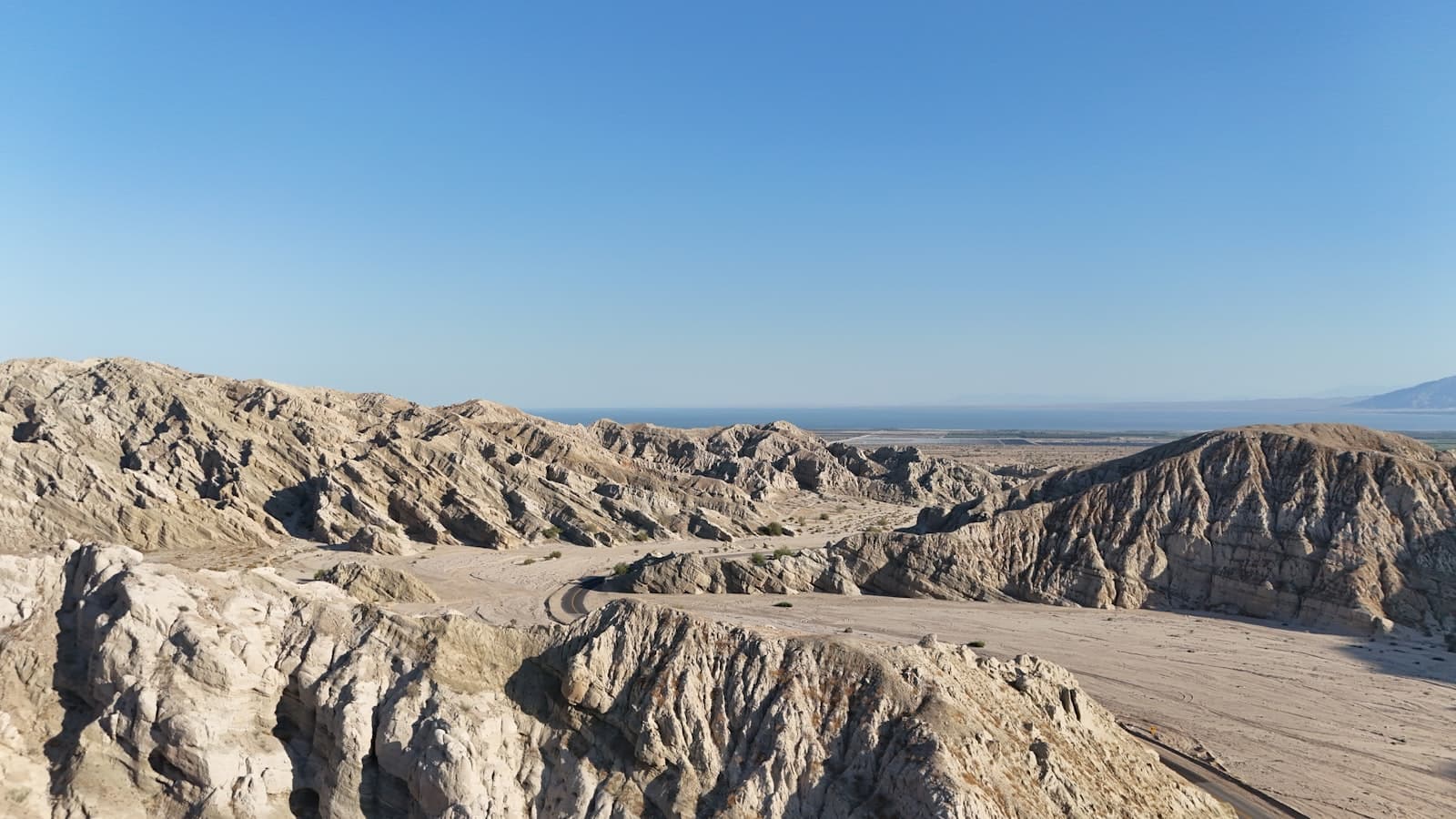
The Slot is the best thing in Anza-Borrego, and it wants first light. It is a walk rather than a drive, down inside the eroded badlands, and it is the stop the rest of the day gets arranged around. Everything else moves to make room for it.

After that the day comes back toward town: a ranger holding current road information, the park's signature canyon hike, a long lunch out of the sun, and a drive past the metal animals standing loose all over the valley floor. It finishes on a paved overlook, and then on a sky with nothing in it.

One condition sits on top of all of it. This is a cool-season route, roughly October through April. Summer heat on the desert floor is life-threatening, Coyote Canyon closes June 1 through September 30, and the Visitor Center drops to weekends and holidays from June through September. At the end of July this is a trip to plan, not a trip to take.

When the forecast finally comes down, check the park's road table the morning you leave, carry far more water than the distances suggest, and get the walking done while the air is still cold.

The hike guide is the better place to compare standalone trails, the camping guide covers sleeping in the park, and the Julian itinerary is the mountain version with indoor stops and a shorter drive. The broader things-to-do guide is the fallback when the desert forecast says no.

Enter The Slot at First Light

BUTTES PASSPRE-TRIP CLEARANCE2WD BASELINEFLASH-FLOOD RULE

A narrow sandstone passage cut down into the badlands off Buttes Pass, and one of the strangest pieces of geology in the park. You walk it rather than drive it, and you walk it at first light, while the canyon is still cool and nothing else has started yet. The approach is dirt: the posted baseline calls it passable for a standard car but sandy and washboarded, which is a description rather than a promise. Clear the road and the forecast before you leave home, then go early and let this be the first thing you see all day.

The move
Walk the narrows at first light, after clearing road and weather before you leave home.
Heads up
Slot canyons flash-flood. Skip this completely for rain risk, extreme heat, uncertain road status, or a vehicle that is not handling the sand confidently.
Daylight only
Buttes Pass Rd off Highway 78, Borrego SpringsDirections →

Anza-Borrego Visitor Center

PALM CANYON DR$10 LOTRANGER RESETSEASONAL SCHEDULE
4.8 Google (1,820) Verified Jul 18, 2026

This is where the day gets its real plan. There are maps, exhibits, a park film, and a garden of native plants outside that hands you the names of everything you are about to walk past — but the thing worth queueing for is the person behind the desk who knows what the roads did last night. Ask about Palm Canyon, about wind, about anything the rain touched. Go in before the hike rather than after, and let a ranger rewrite your afternoon if the conditions say so.

The move
Stop here before the hike and rebuild the afternoon around what staff know today.
Heads up
Indoor hours shrink to weekends and holidays June through September. The lot charges a day-use fee and the parking gate closes at 7pm.
Oct–May daily 9am–5pm; Jun–Sep weekends and holidays 9am–5pm
200 Palm Canyon Dr, Borrego SpringsDirections →Site ↗

Borrego Palm Canyon Trail to the Current Grove Viewpoint

PALM CANYON$10 DAY USE3 MILESGROVE CLOSED
4.8 Google (309) Verified Jul 18, 2026

Three miles of rocky canyon that walk you straight into the park's geology, with a real chance of bighorn on the slopes if you keep looking up. The trail ends at a viewpoint over the native fan palms — the first grove itself stays closed after fire damage, so the palms are something you look at rather than stand under. It is still the signature walk out here and the view earns the distance. Start in the morning, keep looking up, and give any animal you see a lot of room.

The move
Hike to the signed viewpoint in the morning and turn back if the heat gets ahead of you.
Heads up
Full sun, rock, exposure, and no water on the trail. Carry far more than a coastal 3-miler needs, and check the current closure map first.
Trailhead parking sunrise–sunset; $10 day use
Borrego Palm Canyon Campground, end of Palm Canyon DrDirections →Site ↗
Let us decide your next San Diego move.
Verified openings, one neighborhood plan, and the places worth booking. No filler. Join the early list. We’ll email you when the first issue launches.
By subscribing, you agree to receive The Shortlist by email every Sunday. Free; unsubscribe anytime. See our privacy policy. Questions about The Shortlist?

Carlee's Place

BORREGO SPRINGS$$LUNCH RESETDAILY 11–9
4.4 Google (1,460) Verified Jul 18, 2026

Burgers, comfort food, generous plates and cold drinks, in the middle of town, every day of the week. After a morning of rock and full sun that is not a modest offer — it is most of the reason the afternoon still works. The room is friendly and a little bar-shaped, locals are in it, and nobody is rushing you anywhere. Take the whole hour indoors. Everything left on the list happens outside.

The move
Eat something simple, then refill every water bottle in the car before you leave town.
Heads up
Service pace varies and peak crowding is real. If the room is backed up, order simply rather than losing the afternoon to a long lunch.
Daily 11am–9pm
660 Palm Canyon Dr, Borrego SpringsDirections →Site ↗

Galleta Meadows Sculpture Loop

BORREGO SPRINGS RDFREE130+ SCULPTURESUSE THE 2026 MAP
4.8 Google (537) Verified Jul 18, 2026

More than 130 metal sculptures stand around the valley floor in roughly 50 groupings, and the serpent is the one everybody drives out for. Past it there are dinosaurs, long-extinct animals, farmworkers, and creatures that still live out here, which is why one roadside photograph never covers it. It costs nothing. Use the current steward map, take the south cluster and then the north, and get out of the car at the ones that stop you.

The move
Take the mapped south and north clusters as one loop, serpent included.
Heads up
Sandy shoulders vary. Keep the vehicle on existing tracks, never drive close to a sculpture, and skip any pull-off you might not get out of.
Verify posted access; visit in daylight
Borrego Springs Rd, north and south of townDirections →Site ↗

Use the Paved Montezuma Grade View by Default

S-22PAVED DEFAULTFONT'S POINT 4WD ONLYDAYLIGHT EGRESS

Take the paved version. Montezuma Grade climbs S-22 out of the valley and the whole desert floor opens up behind you, from a road any car can handle. Font's Point is the other option and it is not the default — the posted table rates its wash 4WD/poor, with deep sand and S-curves that are difficult even in four-wheel drive. Substitute it only after a same-day ranger, road and weather check, with clearance, recovery gear, fuel, water, and daylight to get back out. Otherwise stay on pavement and watch the light move across the badlands from up there.

The move
Pull over on paved S-22 for the desert-floor view and treat Font's Point as a daylight-only option.
Heads up
Cell service is unreliable and self-rescue planning is mandatory off pavement. Never enter a wash for sunset when darkness will hide the exit conditions.
Complete any dirt-road substitution in full daylight
Montezuma Valley Rd / S-22 west of Borrego SpringsDirections →

Finish at a Mapped Borrego Dark-Sky Pull-Off

BORREGO VALLEYFIVE MAPPED OPTIONSSCOUT BY DAYWEATHER DEPENDENT

Borrego Springs protects its darkness on purpose, and on a moonless night the sky out here does the thing you have otherwise only seen in photographs. The Dark Sky Coalition maps five locations with parking that actually works — the north end of Di Giorgio Road is one of them. Choose yours in daylight, look at the surface and the posted signs, then come back after full dark. Get the car completely off the roadway, kill the headlights, and give it a few minutes.

The move
Scout a mapped pull-off in daylight and return to that exact spot after full dark.
Heads up
Bring warm layers, water, a red-light flashlight, and a firm departure cutoff. Skip the stop if the drive home no longer feels alert and controlled.
After dark only when access, weather, moon, and driver condition support it
Choose one location from the current Borrego Dark Sky Coalition mapDirections →

Where they are

Guide locations · exact streets
Boundary map · every pin links to its entry
Focus spotsHover, focus, or tap

How we built this itinerary

every place has a verified Google or Yelp listing; both are attempted, open status is checked, and evidence is dated.

Road status, trail closures, seasonal hours, ratings, and dark-sky logistics re-verified July 19, 2026

Common questions

When is the best time for an Anza-Borrego day trip?

The cool season, roughly October through April, and check the exact forecast even then. That is when the hiking is survivable, the Visitor Center is open daily, and the dirt-road segments are worth attempting at all. Anything outside that window is a different and much riskier trip.

Can you do this route in summer?

No. Do not take this itinerary out there in July or August. Summer heat on the desert floor is life-threatening, Coyote Canyon closes June 1 through September 30, the Visitor Center drops to weekends and holidays from June through September, and the day ends with a long drive home in the dark. Wait for a cool forecast rather than trying to outsmart the season.

When do the Anza-Borrego wildflowers bloom?

There is no date you can book against. A bloom depends on when the rain came, what the temperature did afterwards, and how hard the wind blew, and it can be spectacular one spring and barely happen the next. Follow the official bloom report before you drive out, and treat flowers as a bonus rather than the reason for the trip.

Do you need four-wheel drive in Anza-Borrego?

Not for the standard version of this route. The Visitor Center, Palm Canyon, Carlee's, the sculptures, and the Montezuma Grade drive are all paved access. The currently posted baseline rates the Buttes Pass approach to The Slot 2WD/good but sandy and washboarded. Font's Point Wash is 4WD/poor with deep sand and is only a daylight substitution after a same-day check.

Is the first Borrego Palm Canyon grove open?

No. State Parks still shows the first palm grove closed after fire damage, and the trail now ends at a viewpoint looking over it. You see the native fan palms rather than walking into them, and the viewpoint is still worth the 3 miles.

Is the Anza-Borrego Visitor Center open in summer?

Only on weekends and holidays. Indoor operations run daily 9am–5pm from October through May and shrink to weekends and holidays 9am–5pm from June through September. The lot charges a day-use fee and the parking gate closes at 7pm, which matters if you are staying out for the stars.

Where should you park for stargazing in Borrego Springs?

Use the Borrego Dark Sky Coalition's current map of five locations with suitable parking — the north end of Di Giorgio Road is one of them. Scout the exact pull-off in daylight, check the surface and the posted signs, and only come back after dark if the weather, the moon, and the driver are all in good shape.

How current are these details?

Road status, trail closures, seasonal hours, ratings, and dark-sky logistics were checked on July 19, 2026. The park's road table is a dated baseline, not a guarantee — recheck it and the forecast the morning you drive out.

Sources and verificationOfficial pages, exact review listings, and reporting used to verify this guide.

Official and first-party sources

About the author

The San Diego List blue asterisk editorial mark
By

Independent San Diego guide publisher

The San Diego editorial team behind independently ranked restaurant, neighborhood, event, and activity guides, with dated evidence and a public corrections process.

Keep planning

Read this next

A City of Encinitas Coastal Rail Trail sign beside the road in CardiffUp next · Outdoors & ViewsThe 10 Best Bike Rides in San DiegoPedal San Diego's breezy bay loops, protected city miles, and dirt-trail mornings on ten rides that make the day feel bigger once you are moving.10 ranked · Updated Aug 2 Keep reading →

More like this